Hi Geoff – thanks for the visuals. That fits well with my ‘feeling’ of how things lie.
But I wonder why you suggest that the Morass feeds into the Mulwaree? If Lake Bathurst is self-contained (which I agree, I think it is, perched in a depression between the Mulwaree River heading north and the
many tributary creeks that flow east into the Shoalhaven), then surely the Morass, which is on the far side of Lake Bathurst from the Mulwaree, is also part of the Lake Bathurst depression (perhaps as an overflow, perhaps within its own (2) smaller depressions.
All very interesting, and just a little bit weird. I wonder if Michael Lenz, with all his years of experience surveying the area, can shed any light or provide confirmation?
Harvey
Dr Harvey Perkins
CRC Programme Liaison Officer
Phone
+61 2 6213 7472
Email:

From: Geoffrey
Dabb [
Sent: Tuesday, 9 June 2015 12:22 PM
To:
Subject: [canberrabirds] FW: AOI catchments
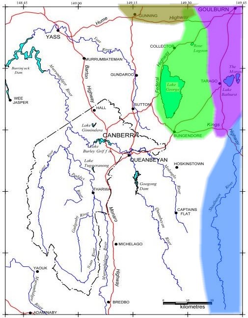
Returning to the matter of the Rose Lagoon catchment, it does seem that it and Wollogorang Lagoon lie within a basin where the waters are locally contained, the main repository being Lake George although the smaller ones are independent
of it, separated by divides of only a few metres height. Wollogorang Creek passes by the lagoon of that name and meanders north of the Hume Highway, just failing to reach the depression
that is the start of the Lachlan (olive shading). Superimposing the approximate catchment boundaries on the AOI map gives quite a complex picture, surely one of the more interesting AOIs, hydrologically speaking, of any national capital. No doubt others
will know more detail. For example Lake Bathurst is possibly self-contained, while the nearby ‘The Morass’ feeds into the Mulwaree/Wollondilly (violet shading), which used to reach the Hawkesbury before being contained by Warragamba Dam.
And to where does Whiskers Creek flow? The white area is the Murrumbidgee catchment.
Between Canberra and Braidwood, the Kings Highway passes through 4 catchment areas. Corrections happily received.
*************************************************************************
The information contained in this e-mail, and any attachments to it,
is intended for the use of the addressee and is confidential. If you
are not the intended recipient you must not use, disclose, read,
forward, copy or retain any of the information. If you received this
e-mail in error, please delete it and notify the sender by return
e-mail or telephone.
The Commonwealth does not warrant that any attachments are free
from viruses or any other defects. You assume all liability for any
loss, damage or other consequences which may arise from opening
or using the attachments.
The security of emails transmitted in an unencrypted environment
cannot be guaranteed. By forwarding or replying to this email, you
acknowledge and accept these risks.
*************************************************************************
|