Just found this… (from
http://www.ga.gov.au/corporate_data/14818/Rec1995_023.pdf )
(sorry to all those not interested)
Lake Bathurst drainage basin has an area of 115 sq. kms and lies within the Southern Tablelands
of New South Wales. The bedrock geology consists of deformed Palaeozoic sediments intruded
by granite ("Lake Bathurst Granite"). In situ deep weathering of bedrock is widespread and
equates with an early-mid Tertiary landscape. Palaeogene rocks are represented by fluvial and
colluvial sediments cemented to ferricrete and silcrete, while Eocene basalt is capped by bauxite.
There is no evidence for a Neogene sequence. The Quaternary is represented by fluvial, colluvial,
lacustrine, strandline and aeolian sediments variably modified by pedogenesis. Drilling indicates
this sequence exceeds 40 m in thickness and has a minimum age coincident with the first
palaeomagnetic reversal at 780,000 yrs BP.
The drainage basin lies along the watershed separating the Wollondilly and Shoalhaven
catchments and is an elevated remnant of the ancient Shoalhaven Plain. It probably originated
in the Late Tertiary by drainage disruption caused by lowering of the base level of the
Shoalhaven river and partial capture of the headwaters of Mulwaree creek. Alluvial aggradation
by Mulwaree creek across this area of indefinite drainage was probably the main process leading
to basin closure. Quaternary climate change is reflected in a complex basin morphology. Smaller
lakes are separated by wave-built sand barriers in and around Lake Bathurst and clay-rich
lunettes at the at the eastern margin of the Morass. The highest palaeoshoreline at approximately
680m above sea level is taken as evidence for a Late Quaternary megalake. Modern landscape
processes are attributed to anthropogenic occupation. Removal of the natural tree cover has
caused dryland salinity, gully erosion and incipient slope instability.
The hydrology of the basin has been investigated since 1981. The Morass is an ephemeral "flowthrough"
lake fed mainly by runoff; it is in hydraulic connection with Lake Bathurst through a
lkm wide sand barrier. Converging groundwater flow paths, perched groundwater seepages and
maintenance of water over long periods indicate Lake Bathurst is an internal discharge area.
Water levels in the lakes respond synchronously to seasonal variation in climate but during
sustained dry periods it is probable that Lake Bathurst will retain water for longer than the
Morass. Hydrochemical data shows Lake Bathurst is a NaCl rich water and is consistently ten
times more saline than the Na-HCO3-C1 water in the Morass. The groundwater hydrology is
essentially an interaction between aquifers in unconsolidated Cainozoic sediments and the lakes.
In most cases groundwater recharge is directly from rainfall. The monthly water balance data
(1987-1994) shows most recharge is accomplished in winter months when rainfall exceeds
evaporation. The close juxtaposition of these saline and freshwater wetlands with their
contrasting ecologies is an unusual occurrence in the tableland areas of New South Wales.
Harvey
Dr Harvey Perkins
CRC Programme Liaison Officer
Phone
+61 2 6213 7472
Email:

From: Perkins,
Harvey
Sent: Tuesday, 9 June 2015 1:08 PM
To: 'Geoffrey Dabb';
Subject: RE: [canberrabirds] AOI catchments [SEC=UNOFFICIAL]
Hi Geoff – thanks for the visuals. That fits well with my ‘feeling’ of how things lie.
But I wonder why you suggest that the Morass feeds into the Mulwaree? If Lake Bathurst is self-contained (which I agree, I think it is, perched in a depression between the Mulwaree River heading north and the
many tributary creeks that flow east into the Shoalhaven), then surely the Morass, which is on the far side of Lake Bathurst from the Mulwaree, is also part of the Lake Bathurst depression (perhaps as an overflow, perhaps within its own (2) smaller depressions.
All very interesting, and just a little bit weird. I wonder if Michael Lenz, with all his years of experience surveying the area, can shed any light or provide confirmation?
Harvey
Dr Harvey Perkins
CRC Programme Liaison Officer
Phone
+61 2 6213 7472
Email:
From: Geoffrey
Dabb
Sent: Tuesday, 9 June 2015 12:22 PM
To:
Subject: [canberrabirds] FW: AOI catchments
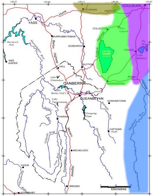
Returning to the matter of the Rose Lagoon catchment, it does seem that it and Wollogorang Lagoon lie within a basin where the waters are locally contained, the main repository being Lake George although the smaller ones are independent
of it, separated by divides of only a few metres height. Wollogorang Creek passes by the lagoon of that name and meanders north of the Hume Highway, just failing to reach the depression
that is the start of the Lachlan (olive shading). Superimposing the approximate catchment boundaries on the AOI map gives quite a complex picture, surely one of the more interesting AOIs, hydrologically speaking, of any national capital. No doubt others
will know more detail. For example Lake Bathurst is possibly self-contained, while the nearby ‘The Morass’ feeds into the Mulwaree/Wollondilly (violet shading), which used to reach the Hawkesbury before being contained by Warragamba Dam.
And to where does Whiskers Creek flow? The white area is the Murrumbidgee catchment.
Between Canberra and Braidwood, the Kings Highway passes through 4 catchment areas. Corrections happily received.
*************************************************************************
The information contained in this e-mail, and any attachments to it,
is intended for the use of the addressee and is confidential. If you
are not the intended recipient you must not use, disclose, read,
forward, copy or retain any of the information. If you received this
e-mail in error, please delete it and notify the sender by return
e-mail or telephone.
The Commonwealth does not warrant that any attachments are free
from viruses or any other defects. You assume all liability for any
loss, damage or other consequences which may arise from opening
or using the attachments.
The security of emails transmitted in an unencrypted environment
cannot be guaranteed. By forwarding or replying to this email, you
acknowledge and accept these risks.
*************************************************************************