Yes, Malcolm Fyfe I should have said, thanks Philip, and thanks for comments to Paul, Martin, Harv. Below are examples of the Bonzle imagery under discussion.
It seems to me a ground check is needed. From memory the ‘Wollogorang Creek’ sign is about at the violet star. In this soggy area the highway is of course built up but with under the road drainage channels and I think from memory there is one of some kind
at the green star. It looks to me that the relief imaging in the Bonzle graphics is based on photography but the water features are drawn, possibly inferred. Note both spellings of ‘R - - e’.

From: Martin Butterfield [
Sent: Thursday, 4 June 2015 3:49 PM
To: Paul Fennell; COG List
Subject: Re: [canberrabirds] Divided opinions
I hadn't, because I find their style somewhat annoying. I now have, and either:
-
Harvey is correct and it is a self-contained system; or
-
There is a possible outflow to the NW. from a point somewhat South of the rest area. If that is the go, it would seem possible that it eventually ends up in Collector Creek and thus Lake George.
I can foresee an expedition at some point to check this out. And of course to look for anything that has been Bitten.
On 4 June 2015 at 15:33, Paul Fennell <> wrote:
Martin
Have you looked at Bonzle? It is handy for relief map views and catchments.
Paul
From:
Martin Butterfield [
Sent: Thursday, 4 June 2015 11:46 AM
To: COG List
Subject: Fwd: [canberrabirds] Divided opinions
see following message. Original rejected as over 200kB. Not quite sure how it got that big
---------- Forwarded message ----------
From: Martin Butterfield <>
Date: 4 June 2015 at 11:39
Subject: Re: [canberrabirds] Divided opinions
To: Geoffrey Dabb <>
Cc: COG List <>
Rather than try to fiddle with elevations on Google Earth (and not having a hard copy topographic map covering the Lagoon with Many Names
- hereafter LMN) I went looking for an online topographic map. The best I could come up with was
this one from Geoscience Australia. Astonishingly it uses the 'alternate name of Tarago Lagoon! Even more astonishingly the contours are in feet, rather than metres - unless there has been some astonishing orogeny in recent days!
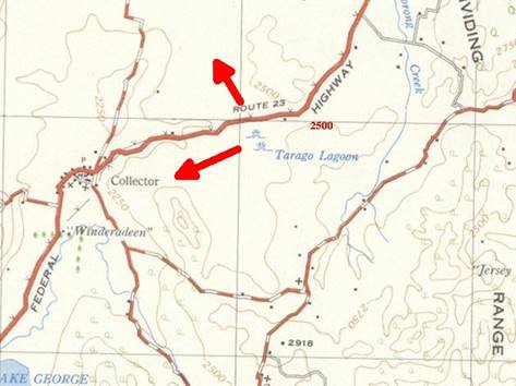
2500m is 762 m and 2250 feet is 685m. >From looking at the contours, the country to the ENE of LMN is closer to 762 m and thus there is unlikely to be be flow
from the lagoon that way. Possibilities are going NW towards a string of lagoons South of Breadalbane - but I think there is a low ridge to the North of the Highway - or, my bet, SW towards Lake George.
|
|