 |
canberrabirds
|
|
|
canberrabirds
|
| To: | COG List <> |
|---|---|
| Subject: | Fwd: [canberrabirds] Divided opinions |
| From: | Martin Butterfield <> |
| Date: | Thu, 4 Jun 2015 01:45:44 +0000 |
|
see following message. Original rejected as over 200kB. Not quite sure how it got that big
Martin Butterfield
---------- Forwarded message ----------
From: Martin Butterfield <> Date: 4 June 2015 at 11:39 Subject: Re: [canberrabirds] Divided opinions To: Geoffrey Dabb <> Cc: COG List <> Rather than try to fiddle with elevations on Google Earth (and not having a hard copy topographic map covering the Lagoon with Many Names - hereafter LMN) I went looking for an online topographic map. The
best I could come up with was
this one from Geoscience Australia. Astonishingly it uses the 'alternate name of Tarago Lagoon! Even more astonishingly the contours are in feet, rather than metres - unless there has been some astonishing orogeny in recent days!
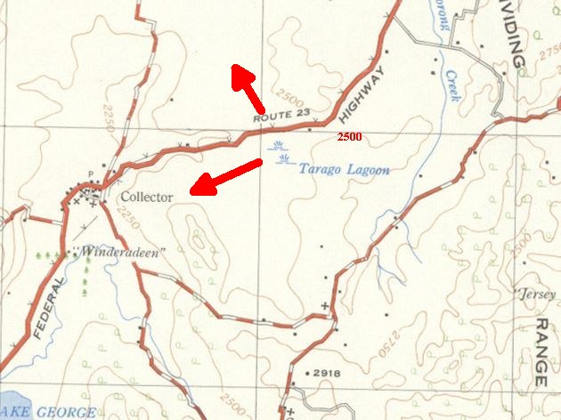 2500m is 762 m and 2250 feet is 685m. From looking at the contours, the country to the ENE of LMN is closer to 762 m and thus there is unlikely to be be flow from the lagoon that way. Possibilities are going NW towards a string of lagoons South of Breadalbane - but I think there is a low ridge to the North of the Highway - or, my bet, SW towards Lake George. Martin Butterfield
|
| <Prev in Thread] | Current Thread | [Next in Thread> |
|---|---|---|
| ||
| Previous by Date: | Divided opinions [SEC=UNOFFICIAL], Perkins, Harvey |
|---|---|
| Next by Date: | FW: Nomadic birds at risk to be saved by citizen science, Julian Robinson |
| Previous by Thread: | Divided opinions [SEC=UNOFFICIAL], Perkins, Harvey |
| Next by Thread: | FW: [canberrabirds] Divided opinions, Geoffrey Dabb |
| Indexes: | [Date] [Thread] [Top] [All Lists] |
The University of NSW School of Computer and Engineering takes no responsibility for the contents of this archive. It is purely a compilation of material sent by many people to the Canberra Ornithologists Group mailing list. It has not been checked for accuracy nor its content verified in any way. If you wish to get material removed from the archive or have other queries about the list contact David McDonald, list manager, phone (02) 6231 8904 or email . If you can not contact David McDonald e-mail Andrew Taylor at this address: andrewt@cse.unsw.EDU.AU