I’ve been to Brandy Flat hut a couple of times recently, from Glendale.
The hut is fine, as are its surroundings.
My overall impression was that the valleys were green but the hills showed signs of burning.
And even in the valleys, the green was grass. Very little undergrowth.
David
From: Canberrabirds
[ On Behalf Of
Sent: Wednesday, November 25, 2020 5:46 PM
To:
Subject: [Canberrabirds] 2020 fires - where burnt, and where you can go
Chatliners who share my difficulty in understanding exactly where the Jan/Feb fires affected may be interested in two maps I cobbled together.
- The first shows the fire boundaries within the ACT (red outline) and outside ACT (black hash), together with the area still closed to the public (within blue outline).
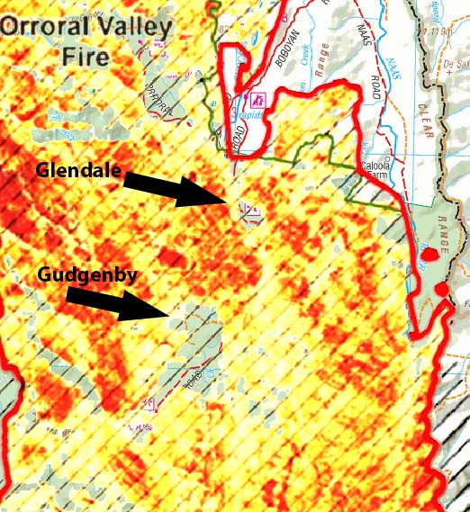
- The second shows in detail the fire intensity map. This is useful to pick the small areas still unburnt or lightly burnt that might be worth a visit – the patches where you
can see through the yellow to the map beneath. It seems to be reasonably accurate – if you drive along Boboyan Road you will see the indicated unburnt areas at Glendale Depot and around Gudgenby homestead.
Both maps can be zoomed to the detail shown in sample below.
https://drive.google.com/file/d/1t_G1OLtP3OtP4DGCT7P_VKLTtUyLLF9C/view?usp=sharing Fire coverage and closed
areas
https://drive.google.com/file/d/1JwihTaJ4s9_v9uO-5uO0l94Smt6hQbXb/view?usp=sharing Fire coverage and intensity
Some interesting points:
- The very southern part of Namadgi around Brayshaws Hut is open and unburnt.
- Of the huts that survived in 2003, Demandering and Oldfields huts were destroyed this time, but Hospital Creek, Horse Gully, Tennent, Westermans, Brayshaws, Waterhole, Pryors
all survived. Nobody seems to know the fate of Brandy Flat or Bog huts.
- Honeysuckle Creek area was severely burnt, as well as Booroomba Rocks - Mt Tennant.
- Only the southern part of Tidbinbilla was burnt.
- There seem to be unburnt areas to the south of Corin Road (I haven’t, but many people will have been there, not sure if Square Rock walk is affected)
- Mt Gingera all burnt, but Mt Ginini and the nearby flats were OK.
- All of the upper Cotter catchment seems to have burnt
- Some closed areas will re-open next year, but others apparently won’t until 2023(!
☹)
I’d be interested in any corrections or further info.
Julian