 |
canberrabirds
|
|
|
canberrabirds
|
| To: | "Geoffrey Dabb" <> |
|---|---|
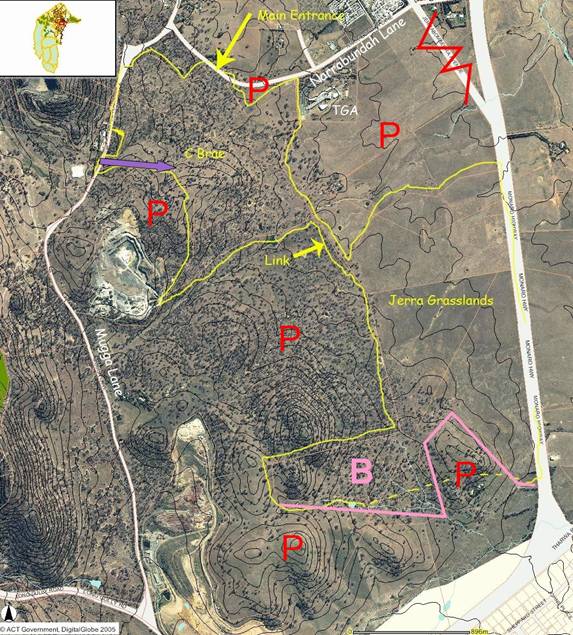
| Subject: | Callum Brae MAP |
| From: | "martin butterfield" <> |
| Date: | Tue, 18 Sep 2007 17:49:48 +1000 |
|
Julian/Geoffrey
What every map, especially a splendid example such as that, needs is a field test. Thus I have taken the liberty of printing a couple of copies - one greyscale, one in Glorious Technicolour (for the benefit or Mr Gates, note correct spellings - to inform the Wednesday Walk tomorrow.
Martin
On 9/18/07, Geoffrey Dabb <> wrote:
|
| <Prev in Thread] | Current Thread | [Next in Thread> |
|---|---|---|
| ||
| Previous by Date: | Callum Brae MAP - correction, Julian Robinson |
|---|---|
| Next by Date: | FW: How to tell you weren't Mum's favourite [SEC=UNCLASSIFIED], Lashko Susan |
| Previous by Thread: | Callum Brae MAP, Geoffrey Dabb |
| Next by Thread: | Silver gulls with nests and young [SEC=UNCLASSIFIED], Whitworth, Benjamin - BRS |
| Indexes: | [Date] [Thread] [Top] [All Lists] |
The University of NSW School of Computer and Engineering takes no responsibility for the contents of this archive. It is purely a compilation of material sent by many people to the Canberra Ornithologists Group mailing list. It has not been checked for accuracy nor its content verified in any way. If you wish to get material removed from the archive or have other queries about the list contact David McDonald, list manager, phone (02) 6231 8904 or email . If you can not contact David McDonald e-mail Andrew Taylor at this address: andrewt@cse.unsw.EDU.AU